

Threats to Endangered Wildlife ~ NASA Images of Deforestation in Virunga
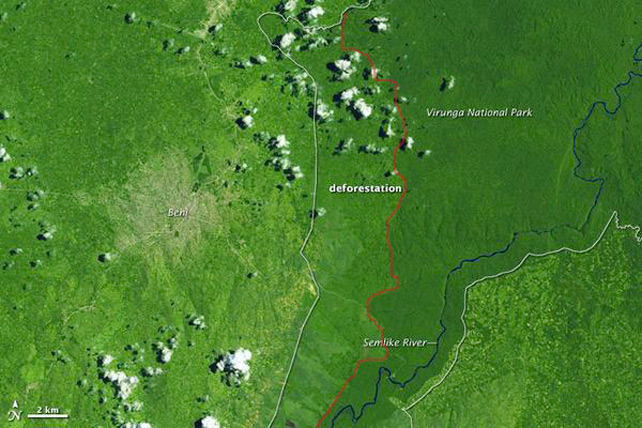


Gorilla CD Field Report ~ NASA recently released some photos of Virunga National Park, comparing the forests from 1999 to 2008 in the northern sector of the park. The photos show significant deforestation along the borders. The rate of forest loss shown in these two images is the highest among all national parks in the Democratic Republic of Congo (DRC), according to the study.
Satellite photos reveal forest destruction in DRC
October 2012. Flying hundreds of kilometres above the Earth, satellites rarely see the human suffering from war and poverty. But decades of unrest have left a very visible impact on the Democratic Republic of the Congo (DRC).
The DRC contains half of Africa’s tropical forest and the second largest continuous tropical forest in the world. Because of unrest and economic instability, the Democratic Republic of the Congo has mostly escaped the industrial-scale deforestation that has taken place in other tropical countries such as Brazil and Indonesia. The exception is near the country’s eastern border, around Virunga National Park.
Mountain gorillas under threat
Home to critically endangered mountain gorillas, the forests have been disappearing quickly as population growth and violence have driven people into the resource-rich forest in and around the park. Subsistence slash-and-burn agriculture and charcoal production have eaten away at the trees, transforming deep green forests into pale savannah grasslands.
In the images below, the space between the left white line and the red line shows the deforestation. The forests have been disappearing quickly as population growth and wars send people into the forests in and around the park to cut trees for charcoal or clear forests for agriculture.
1999 – 2008 deforestation images
The Landsat 5 satellite obtained the top image on February 13, 1999, and the lower image on September 1, 2008. (More recent images of the region were cloudy.) The city of Beni is tan and grey, while the forested Virunga National Park is dark green. The blue Semlike River meanders northeast through the park. The rate of forest loss shown in these two images is the highest among all national parks in the country.
NASA EARTH OBSERVATORY IMAGES BY JESSE ALLEN AND ROBERT SIMMON, USING LANDSAT DATA FROM THE USGS GLOBAL VISUALIZATION VIEWER AND PARK BOUNDARY DATA FROM PROTECTED PLANET. CAPTION BY HOLLI RIEBEEK.
Image Below: 13 February 1999

Image Below: 1 September 2008
(More recent images were cloudy)
Forest loss across the DRC
As a whole, the Democratic Republic of the Congo contains 159,529,000 hectares (615,942 square miles) of forest. Between 2000 and 2010, the country lost 3,711,800 hectares (14,331 square miles) of it, according to a recent analysis of Landsat data completed by Peter Potapov and a team of researchers from South Dakota State University, the University of Maryland, and the Observatoire Satellital des Forêts d’Afrique Centrale. The study by Potapov is the first to survey the entire country since the U.S. Geological Survey made Landsat data available for free in 2008.
Understanding tropical deforestation is important because forests store vast amounts of carbon. Deforestation releases carbon to the atmosphere and prevents the forest from taking up more carbon. Tropical forests also sustain a wide array of plants and animals.
ARTICLE SOURCE: http://www.wildlifeextra.com/go/news/virunga-forest.html#cr
Between 2000 and 2010, the Democratic Republic of Congo lost 14,331 square miles (3,711,800 hectares) of its forests, according to a recent analysis of Landsat data completed by Peter Potapov and researchers from South Dakota State University, the University of Maryland, and the Observatoire Satellital des Forêts d’Afrique Centrale.
Galiwango Obulamu Bw'ekisodde (Translated: The life of a mountain Gorilla) is a 3D animated film about the story of an orphaned mountain Gorilla called Galiwango. The film explores the challenges that Galiwango encounters when he is captured and sold as a baby on the black market by Kasobeza, a former ranger turned rebel, to an illegal animal trafficking ring leader called Musawo (meaning the Doctor) .
FB Comments
Share This Article
Leave a Reply to Anonymous


-
Galiwango Film Voice Acting Session at Fenon Studios in Kampala, Uganda

-
Official Statement from Chief Warden de Merode regarding the recent events

-
National Geographic Report ~ Warden Emmanuel de Merode, Wounded in Africa’s Oldest National Park Had Enemies

-
World Ranger Day 2013: Message from the CITES Secretary-General, John E. Scanlon

-
Zoos and Field Conservationists Call for Worldwide Action to Stop Illegal Killing of Wildlife ~ ZACC Conference 2013

-
Virunga Field Report ~ Anti-Charcoal Patrol Results in Arrests

-
Africa: UN Recognizes Wildlife Trafficking as a ‘Serious Crime’

-
Gorillas Caught in the Crossfire in the Democratic Republic of Congo

-
UN: East Africa leads Ape Tourism Globally

-
Virunga Report ~ Rangers Deal with Increased Number of Wildlife Snares


Galiwango Film Partner ~ Faceware
Galiwango Film Partner ~ Mixamo
Support the Batwa Experience
Visit the Ugandan Diaspora News
© 2009. All Rights Reserved. Galiwango Film, Created, Written, Directed and Animated by Solomon W. Jagwe | www.sowl.com